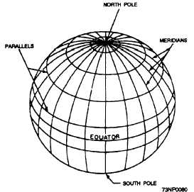
Figure 9-4.—The terrestrial sphere.
Parallels
Parallels also require a reference: the Equator.
The Equator (0°) is located halfway between the poles,
and divides the world into Northern and Southern
Hemispheres. The letter designator (N or S) must also
be used in referencing a position. The principle of the
numbering system is similar to that used for meridians
except that parallels range from 0° at the Equator to
90° N or S at the poles.
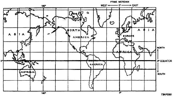
Latitude and Longitude
Every spot on Earth is located at the point of
intersection between a meridian and a parallel. Every
point's location is describable in terms of latitude and
longitude.
Latitude (parallel) is the angular position in
degrees, minutes, and seconds of arc north or south of
the Equator, measured along the meridian of the point.
(See fig. 9-5.)
Longitude (meridians) is the angular position in
degrees, minutes, and seconds of arc east or west of
the 0° meridian, measured along the parallel of the
point. (See fig. 9-5.)
For navigational purposes, accuracy demands are
rigid. The exact position must be designated.
Consequently, in giving navigational position, 1° is
divided into 60 minutes, and 1 minute is divided into
60 seconds. Thus, a latitude may be 45° 12 minutes 22
seconds N (or S). The same system is used for east or
west longitude. In all reports concerning navigation
hazards and positions of lightships, buoys, and the like
received on radio nets or read in Notices to Mariners,
positions are given in latitude and longitude.
Nautical Distance
On Earth's surface, 1° of latitude may be
considered 60 nautical miles in length; whereas the
length of 1° of longitude varies with latitude. Hence,
the latitude scale must be used for measuring distance.
Although this scale is expanded on a Mercator chart,
the expansion is exactly equal to the expansion of
distance at the same latitude. Therefore, in measuring
Figure 9-5.—Earth on the Mercator projection.
9-4