Plotting Aircraft Position Using RADAR and Tactical Air Navigation
An aircraft can determine its position and obtain a fix by using its airborne RADAR and
Tactical Air Navigation (TACAN) systems.
The TACAN is the military counterpart of the civilian VHF omnidirectional range (VOR)/
Distance Measuring Equipment (DME) system. It was developed by the military
because VOR/DME systems were considered unsuitable due to specific military or
naval operations (like unusual site conditions, pitch and roll of naval vessels, etc.) As a
result, the FAA integrated TACAN facilities with VOR/DME programs and called these
new facilities VORTAC.
RADAR Fix
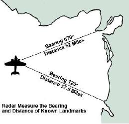
Airborne RADAR is oriented so that the nose of the aircraft represents 360. A
radarscope in the aircraft can be used to provide a fix by determining the relative
bearing and the aircraft s distance from known landmarks. Figure 2-7 gives an example
of a RADAR fix for an airborne aircraft.
Figure 2-7 -- RADAR fix for an airborne aircraft.
TACAN Fix
TACAN provides bearing and distance information. Using aircraft instruments, the pilot
can determine what TACAN radial the aircraft is on and its distance from the TACAN
station. Since the position of the TACAN station is known, a fix, or the aircraft's position,
can be determined relative to the TACAN station. Figure 2-8 shows an example of a
TACAN fix.
2-14

