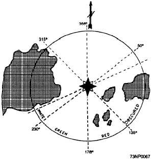
Sectors may be only a few degrees wide, marking
an isolated obstruction, or they may be so wide as to
extend from the direction of deep water to the beach.
A narrow green sector may indicate a turning point or
the best water across a shoal. The exact significance
of each sector must be obtained from the chart.
All sector bearings are true bearing in degrees,
running clockwise around the light as a center. In
figure 9-10, for instance, the bearings of the red
sectors from the light are 135° to 178°. This sector is
defined in Light Lists in terms of bearings from the
ship. These bearings are 315° to 358°, the reciprocals
of the preceding bearings. The light shown in the
diagram would be defined thus: Obscured from land
to 315°, red thence to 358°, green thence to 050°, and
white thence to land.
On either side of the line of demarcation between
colored and white sectors, there is always a small
sector whose color is doubtful because the edges of
the sector cannot be cut off sharply in color. Moreover,
under some atmospheric conditions a white light itself
may have a reddish appearance. Consequently, light
sectors must not be relied upon entirely, but position
must be verified repeatedly by bearings taken on the
light itself or by other fixed objects.
When a light is cut off by adjoining land, the arc
of visibility may vary with a ship's distance away from
the light. If the intervening land is sloping, for
example, the light may be visible over a wider arc from
a far-off ship than from one close inshore.
Figure 9-10.—Light sectors.
BUOYS
Buoys are perhaps the most numerous aids to
navigation, and they come in many shapes and sizes.
These floating objects, heavily anchored to the
bottom, are intended to convey information by their
shapes or color, or by the characteristics of a visible
or audible signal, or by a combination of two or more
of such features.
Large automatic navigational buoys (LANBY) are
major aids to navigation. They provide light, sound
signal, and radio beacon services, much the same as a
lightship. Some LANBYs today are replacing
lightships in U.S. waters. The LANBY is an all steel,
disc-shaped hull, 40 feet in diameter. The light, sound
signal, and radio beacon are located on the mast.
Although buoys are valuable aids to navigation,
as was stated for sector lights, they must never be
depended upon exclusively. Buoys frequently move
during heavy weather, or they may be set adrift when
run down by passing vessels. Whistles, bells, and
gongs actuated by the sea's motion may fail to
function in smooth water, and lights on lighted buoys
may burn out.
MARITIME BUOYAGE SYSTEM
Until recently, there were numerous buoyage
systems in use around the world. In 1982, most of the
maritime nations signed an agreement sponsored by
the International Association of Lighthouse
Authorities (IALA). This agreement adopted a system
known as the IALA Maritime Buoyage System. Two
systems were developed because certain basic
long-established international differences precluded
adoption of a single system worldwide. Both systems,
designated region A and region B, use a combination
of cardinal marks and lateral marks plus unique marks
for isolated danger, safe-water areas, and special
purposes. The cardinal and unique marks are the same
in both systems; the lateral marks are the major
difference between the two buoy regions.
To convey the desired information to the
navigator, the IALA system uses buoy shape, color,
and if lighted, the rhythm of the flashes. Buoys also
provide for a pattern of “topmarks,” small distinctive
shapes above the basic aid, to facilitate its
identification in the daytime from a distance, or under
light conditions when the color might not be easily
ascertained. Figure 9-11 show the international
buoyage regions A and B.
9-11


